The nearby villages of Kirkland & Ennerdale Bridge are on the Coast to Coast Walk, St Bega's Way & Cycle (C2C) routes. The Reivers Cycle route runs from Whitehaven to Tynemouth and the Coast to Coast from Whitehaven to Sunderland.
Accommodation in Ennerdale Bridge is limited so you will need to make reservations early. We are just 1.6 miles outside the village.
Most C2C'rs arrive in the village around 4-5pm and if you are staying with us, we suggest it is best to get an evening meal before either walking up the hill to us or getting a taxi. We recommend Bigrigg Cabs as the most reliable and cheapest (01946 810024) and it is worth booking a cab as soon as you know what time you are eating, as the taxi can take up to half an hour to arrive from Whitehaven. Our check-in is 4-8pm.
![]()
One thing worth mentioning is the food options you may find along the valley, depending how far from the route you are staying.
There are two places for evening meals in the village.
- The Shepherds Arms - 01946 861249
- The Fox and Hounds - 01946 861373
Both can be busy at weekends from Early April onwards, so it is essential to call early to check availability of tables.
If you arrive in Ennerdale Bridge early there is a cafe, The Gather and small shop in Ennerdale Bridge. (Please note we are unable to store food for guests overnight).
We can provide packed lunches for your walk as there are really limited options for food and drink between here and Rosthwaite.
If you are on a walking or cycle route we will need a packed lunch order by 8pm to ensure we have what you require. We usually send a google form to you for check-in, breakfast options and packed lunches on the afternoon of arrival so you can decide over a relaxing drink at the pub, without having to worry about time. Wi-Fi is available in both pubs.
![]()
There is extremely patchy mobile phone service throughout the valley, so you may need to make essential calls before entering Ennerdale or use the payphones or Wi-Fi in the pubs. For Emergency calls we can offer the use of our landline.
Unfortunately we are not able to offer a collection/drop off at Ennerdale Bridge. We do not offer evening meals.
Check-in is not before 4pm unless previously arranged, as we are unable to guarantee anyone will be in to allow access and there are no facilities for guests in the event of poor weather etc.
We will do our best to help you dry wet clothes and boots, however the success is dependent upon what time you arrive and we get them.
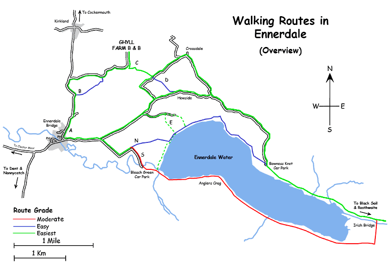
Route A From Ennerdale Bridge to Ghyll Farm B & B
Head towards Kirkland, follow the road uphill. 0.6 miles after you leave the village of Ennerdale Bridge take the right turn down a single track, made up road (don’t take the first unmade track ¼ mile outside the village). There are signs at the junction but look for the remains of an old barn and a timber footpath signpost on the corner of the main road and the lane. Follow the single track road for 0.5m. Take the turning on right signposted “Ghyll Farm” follow the track for further 0.5miles up to the top of the hill.
Route A From Ennerdale Bridge to Ghyll Farm B & B
Head towards Kirkland, follow the road uphill. 0.5 miles after you leave the village of Ennerdale Bridge there is a farm next to the road on a sharp bend. Just past the farm buildings on the left is a footpath and a stile (not always easy to see). Step over the style and follow the field boundaries to the right. When you come to Bank End Barns conversions turn right onto the road. After a short way take the turning on the right signposted “Ghyll Farm” follow the track for further 0.5miles up to the top of the hill.
Route C From Ghyll Farm B & B to Irish Bridge
This route will take you from the B & B to Irish Bridge at the end of the lake. It starts with a pleasant 10 minute walk through our neighbours fields down to the Croasdale Road. This road leads from Ennerdale Bridge all the way to Ennerdale Lake where it becomes a forestry track leading up the valley to Black Sail Youth Hostel. It is a quiet single track road and is the quickest, easiest and dryest way to reach the head of the valley. If you are recovering from a hard first day or want to take in the best of lakelands countryside, without worrying about where you put your feet or looking at a map this is the best route.
Route D From Ghyll Farm B & B to Irish Bridge
This route will take you from the B & B to Irish Bridge at the end of the lake. Essentially it is the same as Route C but instead of following the road to Croasdale, you take the footpath up to Howside farm and follow their track back to the main road. This route can be boggy and wet and is slightly more hilly than Route C.
Route E From Ghyll Farm B & B to Ennerdale Water
This route will take you from the B & B down to the lake. Once you have crossed our neighbours fields and found the road, turn right and follow the road toward Ennerdale Bridge. Take the second turning left, past How Hall farm and the single track road will take you down to the lake. At the lake side you can turn left and follow the path through to Bowness Knot and on to Irish Bridge or turn right and follow the path to pick up the trail on the south side of the lake.
Route N From Ennerdale Bridge to Irish Bridge
This route will take you from Ennerdale Bridge to the lake and around the north shore to Irish Bridge. Follow the road out of Ennerdale Bridge towards the lake at Broadmoor the road splits, left towards Bowness Knot and right to Bleach Green. Take the right turn. After a few hundred yards the road turns sharply left and a short way on turns sharply right with a track straight ahead. Take this track, Sawdust Lonning, and follow it down to the lake shore. At the lake side you can turn left and follow the path through to Bowness Knot. This is probably the driest, flattest route from Ennerdale Bridge in inclement weather.
Route S From Ennerdale Bridge to Irish Bridge
This route will take you from Ennerdale Bridge to the lake and around the south shore to Irish Bridge. It is the traditional "Wainwright's" route and is detailed in the various route books and guides etc. It is the prettiest and quietest route along the lake as there is no road, just a fell path. However it can be a scramble in places and there are a couple of places that can make those without a head for heights a wee bit nervous. The path is a little uneven and can be very wet in bad weather. It is a great walk if you are just doing the lake, but it is not the quickest walk if you are pushed for time to get to Rosthwaite.
![]()
Download and print Routcards with Waypoints above.